|
|
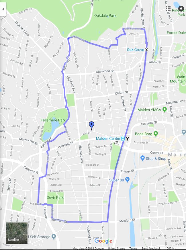
The main boundaries of the Boston Eruv are shown on the map below.
Below are two general sections. The first outlines the external border of the Eruv and the second describes the internal borders (lakes and cemeteries).
External borders
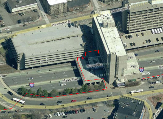
The northwest border of the Eruv extends from Chestnut St. (Newton) along the Massachusetts Turnpike (Route 90) eastwards until the intersection of the Pike with the BU Bridge, then follows Storrow Drive until the Charlesgate area and then rejoins the Pike south of Commonwealth Avenue. (Boston). The Eruv then follows the Mass Pike north fence westwards, crossing over the Brookline Avenue overpass and then crossing over the eastside of the Beacon Street overpass. It then continues through the parking lot near Harvard Pilgrim-Kenmore; then meets the MBTA (Green Line) fence ands heads southwesterly back towards Brookline.
The MBTA line is followed until Brookline Village (Aspinwall St to Brookline Avenue) where the Eruv turns south, crosses over Route 9 just west of the main entrance to the Brook House and then turns down Pond Avenue (the Brook House and its sidewalk on Washington St is in the Eruv). The Eruv continues down Pond Ave. and then follows Chestnut St. north, Walnut St. west and turns onto Warren St south and then leaving Warren to continue down Cottage to Gaddard Ave. The border continues south on Rockland and turns west on Pond St. The border now continues to Newton St to Allendale Rd, south to Hackensack then crossing VFW Parkway until Weld St where it continues west to Corey and north to VFW Parkway. The Eruv then continues west along the middle of VFW Parkway to Kiernan and then onto Brook Farm Rd until Corey. The border then continues north on Corey until Vine and then south on Brookline St until Dedham St and then west on Nahanton St until Winchester St. The Eruv continues on Wallace St until Christina St and then northwest to Oak St. The Eruv turns north on Elliot St and continue across Route 9 to Woodward St and left on Lincoln to the MBTA station and tracks. The tracks are followed until Chestnut St. and then follows Chestnut St. north until the intersection with the Mass. Pike.
The Nonantum Eruv Extension
A segment of the northern border of the Eruv along the Mass Pike extends into West Newton/Nonantum. There are four Pike bridge overpasses that enable people to cross over the Mass Pike (West to East):
- Lowell Avenue
- Walnut Avenue
- Harvard Avenue
- Lewis Terrace
From the western end of the Nonantum section, the Eruv starts at a pole alongside the Mass Pike fence and crosses over Washington St. to Eddy St. The border follows Eddy St. to Albermarle Rd., turns right on Albermarle Rd. and continues under Brookside Ave. The Eruv then turns left on Brookside Ave. and continues to Watertown Street. The Eruv turns right and continue until Linwood St., makes a left on Linwood St. and continues to Walnut St and then turns left and continues until Craft St. The Eruv then makes a left on Craft St. continuing to North St and then turns right and continues until Brookdale Rd. The Eruv then turns right on Brookdale Rd, and continues until Albermarle Rd turning right on Albermarle Rd. and continuing until Nevada St. The Eruv then turns right on Nevada and continues until California St, turns left and continues until Jassett St. and then turns right and continues until Watertown St. The Eruv then turns left and continues until Capital St. then makes a right and continues until Jackson Rd then making a right and continuing until Pearl St. The Eruv then turns left continuing until Gardner St., turns left and continues until School St. From here, the Eruv turns right and continues on Thornton St. which then becomes Waban St. The Eruv turns right on Waban St. and continues to Jewett St. and finally crosses Washington St. to a pole installed at the Mass Pike along the south side of Washington Street.
Note: One needs to exercise caution when walking on Shabbat along any of the street above due to the fact that the Eruv may allow the sidewalk (or roadway) along the street to be "in" or "out" of the Eruv even along the same street. The route above is presented to be used as a guide to the "boundary streets". Anyone walking along these borders on Shabbat needs to be completely familiar with the exact location of the Eruv boundary in these locations.
Internal
Several areas within the Eruv District are self-contained by a Mechitzah in order to exclude them from the Eruv. Sidewalks along these streets must be very carefully walked to prevent one carrying outside of the Eruv on Shabbat.
-
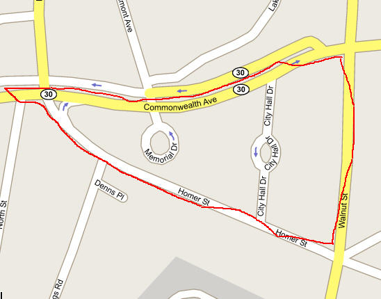
City Hall (Newton) - The City Hall "triangle" is located west of Walnut Street, south of Commonwealth Avenue, and north of Homer Street.
Starting at the corner of Walnut and Commonwealth Ave:
- Along Walnut Street: One may carry only on the eastern, sidewalk side of Walnut Street between Commonwealth and Homer Streets.
- Along Homer Street: One may carry along the west (library) side of the street and to the Newton Public Library. One may only carry only on the "houses" side of the street and only on the sidewalk, not in the street. One must pay careful attention to where the overhead twines are that delineate the border of the Eruv around the City Hall pond.
- Along Commonwealth Avenue: One may only carry when walking in the carriage road between Walnut Street and Lowell Avenue. When reaching Lowell Avenue, one may carry across the traffic light intersection.
[This entire area is should be treated very carefully to protect oneself and family from unwittingly carrying on Shabbat. The appropriateness of entering/using the library on Shabbat should be checked with your Rabbi.]
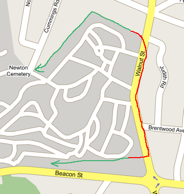
From the corner of Walnut and Commonwealth proceeding southwards, one must stay on the east side of Walnut until Homer and then can proceed on Walnut along either side of the sidewalk until the edge of the Cemetery Fence. {Newton Cemetery} From here until the south end of the cemetery, one must walk only only on the east side of the street (and never IN the street). The sidewalk along the Newton Cemetery is out of the Eruv from north end to south end along Walnut Street. The south end of the border is along the fence between the Walgreen's parking lot and the cemetery.
- [7/6/2007] - The area around Crystal Lake is part of the Eruv.
- Bulloughs Pond (Newton): [6/18/2018] The entire area around this pond is usable due to regular use by residents by kayak, canoe, rowboat, R/C boating, etc... during all four seasons of the year.
- Chandler Pond (Brighton) - [6/24/2018] This entire area in now within the Eruv due to frequent use of the Pond by residents.
- Newton Cemetery (Walnut St.) -The only side of Walnut St. in the Eruv between Newton Four Corners and the northern extent of the cemetery property (abutting the Newton Public Library, south of Homer St.) is the sidewalk on the eastern side of the street.
Additional twines have been placed that span from the light poles coming down Walnut St. from Commonwealth Ave. towards the library (actually to the pole on the southwest corner of Homer and Walnut) then travelling west on Homer until just past the Library parking lot. With these twines in place, the twine coming to the southeast corner is valid but superceded by the twines just described. This way, the entire east side of Walnut street (on the sidewalk) is available to walkers. The original twines were left in-place as a backup. (Note added July 25, 2004)
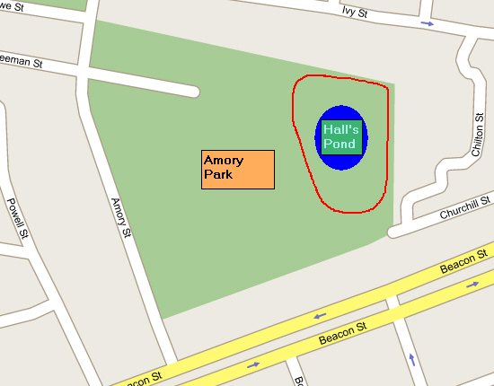
- Hall's Pond (Brookline) - This pond, located east of Amory Park is not in the Eruv. There is a fence all around this Pond area that may not be crossed on Shabbos.
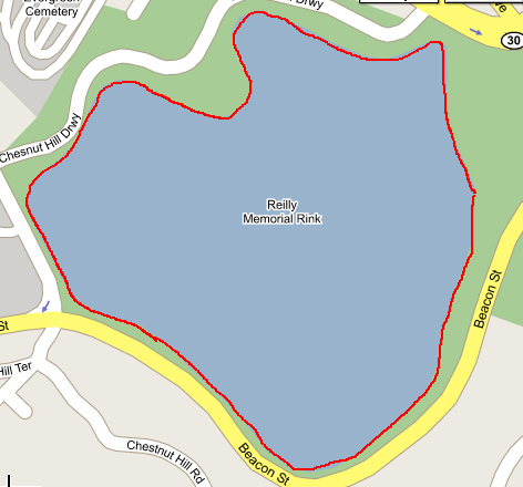
- Chestnut Hill Reservoir (Brighton) - This large reservoir is completely surrounded by an iron fence. This fence is the Mechitzah and one may not carry if on the other side of it on Shabbos. In late 2004, several gaps were made in the fence for people to walk in the interior of the fence. Now, the reservoir is treated like the Brookline Reservoir and so the outside or inside may be traversed on Shabbat.
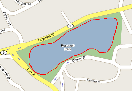
- Brookline Reservoir (Brookline - Off Route 9) - This body of water is completely surrounded by an embedded, angled flagstone wall. The Walking Path around this reservoir is completely available for use on Shabbat. One may not walk down the edges of the slope on Shabbos since the slope is the Mechitzah.
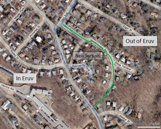
- Glen Road/Westminster Road Extension, November 2010: An enlargement was made to accommodate the homes south of Westminster towards Langley Road and including homes on Glen Road and Bartlett Terrace. The map below shows the general borders. The path that leads through the forest from the cul-de-sac on Westminster up to Langley Road must be carefully traversed to stay to the north of the overhead twine - this is significantly off the walking path - please be careful!
- Newton: Four Points By Sheraton Hotel (as of November 2010): The two Tzurot Ha-Pesah at the hotel allow guests to enter and exit the hotel on Shabbat when carrying only from the south side of the hotel (and not through the automatic electic doors at the main lobby entrance).
Miscellaneous comments regarding egress and borders
Glen Ave. (Newton) [Updated September 22, 2013] - From Beacon Street, one can travel under the Glen Street train underpass until Warren Street. Pay careful attention to staying on the west side of Glen south of Warren and be sure that you don't use the north side of the sidewalk on Warren if walking towards Renee Terrace.
In many cases, the Eruv utilizes existing utility poles with attached lechi-im (thin plastic strips) to form the border. As such, the fact is that (1) some poles may criss-cross the street and (2) some poles may be located between the sidewalk and residential property rather than between the sidewalk and the curb. Here, one may be blocked from using the sidewalk at all in certain spots (There are examples of this latter problem along Route 9 in Newton near Cloverdale St. and near Floral Ave. There are many instances of this in Brookline as well.). If you know that you will be walking on Shabbat near an edge of the Eruv, please consult your Shul Rabbi regarding the exact nature of the Eruv border (or contact us).
Malden Eruv including late-2013 Expansion
North Shore Eruv - Phase 1 Final - 2016
Note: Burrill St underpass cannot be used for getting from the Essex St area to the
Synagogue area due to constraints on how the Eruv border had to be constructed in the
Burrill underpass area. Residents wishing to walk from the section north of the MBTA station at Burrill
have to walk in a northeast direction to the Essex MBTA overpass (and watch what sides of the street they use
there) and then follow the streets back to the southern side of the Burrill St. MBTA underpass.
Updated: January 3, 2023
Back
|